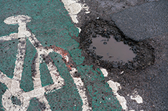
A new pothole reporting system has been launched to mark National Pothole Day, while an old favourite celebrates a re-vamp.
Cycling UK has refreshed its pothole reporting tool, Fill That Hole, which has helped nearly 200,000 defects get reported over the whole of the UK since its launch in 2007.
Data from the new system will also allow Cycling UK 'to monitor how potholes impact different road users for the first time'.
 'Anonymous data will let our campaigns team know the rate of injury or damage caused by potholes for different road users, helping power our push for more long-term funding for local roads maintenance,' the membership charity said.
The new system also lets users report on other problems that could pose a risk such as broken traffic lights, incorrect or damaged signage, or debris on the road.
Cyclists are particularly vulnerable to potholes and up to 15% of cyclists injured in crashes dealt with by Cycling UK’s legal services team said the incident was related to a road defect.
The updated tool was made possible by funding and support from law firm Fletchers Cycle SOS.
Bob Coupland, head of cycling claims at Cycle SOS, part of Fletchers Solicitors, said: 'As legal partners of Cycling UK, we understand the importance of addressing the issue of potholes and road defects for the wellbeing of cyclists.
'This platform not only serves as a valuable tool for reporting potholes but also plays a pivotal role in fostering collaboration between the cycling community and local authorities. The Fill That Hole website aligns seamlessly with our mission to advocate for the rights and wellbeing of cyclists on the road.'
Reports via the app or website go directly to the relevant highway authority, which has a legal responsibility to check and repair where necessary.
Meanwhile, the RAC has also teamed up with Metricell to release the free Stan pothole reporting app, which provides a 'user-friendly AI-powered platform to report and address potholes quickly and hold local authorities to account'.
After downloading the app, users can report a road defect by taking a photo or video with a smartphone – allowing the public to use the same computer vision and geospatial technology that contractors now deploy to monitor roads.
Stan is the public-facing version of Road Surveyor, an enterprise application used by local governments and highway agencies to monitor roads.
The Stan system can identify defects and their location. It then generates a report and connects with local councils to provide detailed information about the number and severity of local defects.
Stan can also create a 'Road Health Score' using a formula involving the number and severity of road defects, traffic volume, and road types 'based on Department for Transport guidelines and consultations with the RAC', the Stan team said.
'With Stan, we are empowering communities to play an active role in ensuring safer roads,' said Mike Mockford, product owner of Stan.
'Our partnership with the RAC is a testament to our commitment to making a real difference, and we are excited about the combined efforts in creating a more secure and reliable road infrastructure.'
RAC head of policy Simon Williams said: 'Pothole-ridden roads are the scourge of every driver, which is why we are so keen to work with Metricell to promote the use of the free Stan app.
'If used by drivers widely enough, Stan has the potential to keep councils informed of all the major road defects on their networks, enabling them to take faster action leading to safer, more comfortable journeys.'