National Highways has published new artist's impressions showing over 60km of new or improved pathways for walkers, cyclists and horse riders that will be delivered as part of the massive Lower Thames Crossing project.
The government-owned company said new or improved bridges and pathways will encourage active travel between parks, woodlands, heritage sites and employment centres.
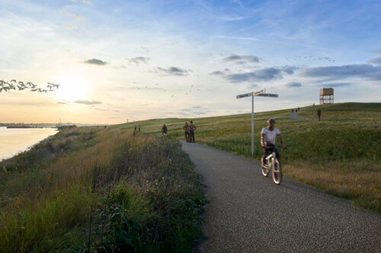
Artist's impression of repaired Two Forts Way foot and cycle path and Tilbury Fields park
The proposals include:
- seven new green bridges to provide ‘safe and easy’ crossings for people and wildlife – including an 84 metre-wide bridge in Kent, ‘one of the widest green bridges in Europe’
- two new footbridges over the A127 and one over the M25 ‘to create safe, easy crossing points and restore links severed by historic road building’
- a network of bridleways giving horse riders an uninterrupted route between woodlands such as Thames Chase Forest, Hole Farm community woodland and the Mardyke in Essex, and Ranscombe Farm Reserve, Ashenbank Wood and Shorne Woods Country Park in Kent
- a new cycle route south of the A2 running through Jeskyns Community Woodland from Park Pale in the east to Hares bridge in the west
- a new 3km foot and cycle path, separated from road traffic, providing a ‘safer and easier’ way to commute between East Tilbury, Linford and Chadwell St Mary
- improved foot and cycle path between the local community and heritage sites such as Coalhouse fort and East Tilbury Battery
Emily Dawson, head of benefits for the Lower Thames Crossing, said: ‘We’re designing the Lower Thames Crossing to work for all, and our plans include over 60km of new or improved paths for walkers, cyclists – almost 3km for every 1km of new road.
‘These will promote active travel and encourage health and wellbeing by better connecting local communities to the area’s rich network of parks and woodland, heritage sites, and places of work and study.’
National Highways said it has also agreed to fund improvements to the wider public rights of way network, which would be delivered ahead of the project.
These include the restoration of a missing link along the popular Two Forts Way near Coalhouse Fort in Thurrock that would be delivered by Thurrock Council, and supporting the Association of South Essex Local Authorities to improve the accessibility of the Coastal Path between Coalhouse Fort and Stanford-le-Hope.
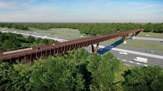
Artist's impression of a new bridge over M25 connecting the Thames Chase Community Forest
In November 2020, National Highways withdrew its application for a Development Consent Order for the project, pledging that it would resubmit ‘early in the new year’. By 2021, this had been put back to the end of that year.
However, in November 2021, the government-owned company announced that it would revise plans for an area of river frontage between the Port of Tilbury and the tunnel entrance in Thurrock to form part of a new public park (pictured) and environmental mitigation for the project, because the land could be needed for a proposed Thames Freeport at Tilbury.
As a result, it said it would submit its DCO application ‘in 2022’.